What if a single misplaced fence post costs you thousands in legal fees or kills your land sale entirely? Most owners assume their boundaries are clear until they actually try to find them in the thick brush. Whether you are dealing with overgrown markers or confusing legal descriptions, the uncertainty is a massive burden on any land owner. You need to know exactly how to find property lines to protect your investment and maintain peace of mind.
You probably suspect that relying on a handshake or a rusted iron pipe isn’t enough. You are right. This pragmatic guide eliminates the guesswork by providing a clear, step by step path to locating your boundaries. We show you how to leverage public records, use the latest digital tools like LandGlide version 5.4.10, and interpret complex deeds without the headache. We will break down the process into simple, actionable steps. You will learn to identify your corners, resolve potential neighbor disputes, and prepare your parcel for a clean, fast listing on the market. Let’s get to work.
Key Takeaways
- Secure your property deed and plat map to define the legal perimeter of your land.
- Master how to find property lines by using metal detectors to locate original iron survey pins.
- Identify the specific scenarios where a professional land survey is the only legally binding solution.
- Prepare your land for a clean listing by mapping boundaries with GIS overlays to reassure potential buyers.
Understanding Property Lines: Why Boundaries Matter for Vacant Land
Property lines define the legal perimeter of your real estate investment. They are the hard boundaries of your equity. On vacant land, these lines often get ignored until a problem arises. You cannot afford that. Identifying boundaries early prevents costly encroachments from neighboring developments or logging operations. If a neighbor builds a road or clears timber three feet onto your side, your land value drops instantly. You lose control of your asset.
Accurate boundary knowledge is essential for calculating total acreage. Land is priced by the acre or square foot. A small discrepancy of ten feet across a long boundary can change your total land value by thousands of dollars. Beyond value, clear lines make vacant land significantly more attractive to prospective buyers. They want certainty. They don’t want to buy a lawsuit. Learning how to find property lines before you list ensures a fast, clean sale without procedural hurdles.
The Difference Between Visible and Legal Boundaries
Physical features are often misleading indicators. A line of old oaks or a rusted barbed wire fence might look like a boundary. Usually, it isn’t. These are physical markers of convenience from decades ago. Legal boundaries are recorded in county archives and property deeds. They are part of the cadastre, which is the official public record of land parcels. Modern GPS coordinates often reveal that “grandfathered” lines are technically incorrect. Rely on the official paperwork, not the landscape. It’s the only way to establish the truth of your parcel’s dimensions.
Risks of Ignoring Property Line Accuracy
Neglect leads to expensive disasters. You might face legal battles over timber rights if a neighbor harvests trees on your side. Access easements are another trap. If you don’t know where your property starts, you might accidentally block a neighbor’s legal access or lose your own. These disputes are draining and avoidable.
Title insurance issues frequently stall land sales. If an underwriter finds a boundary discrepancy, they won’t issue a policy. This kills your deal immediately. Zoning is also a factor. You cannot place a shed, cabin, or fence wherever you like. Most counties require specific setbacks from the property line. Violating these rules results in fines or orders to tear down your structures. Mastering how to find property lines is your first step in avoiding these legal and financial traps.
How to Find Property Lines Using Public Records
The county recorder’s office holds the keys to your land’s identity. Start by pulling your most recent property deed. This document contains the legal description. It is the only text that matters in a dispute. Most rural or undeveloped parcels use a “metes and bounds” system. This system describes the perimeter through a series of directions and distances. Learning how to find property lines through records saves time and money. It prepares you for the physical search on the ground. You know what you are looking for before you ever step foot on the dirt.
Reading Metes and Bounds Descriptions
Locate the “Point of Beginning” (POB) in your deed. This is the specific corner where the legal description starts. From there, the text will guide you through “bearings and distances.” For example, it might say “North 20 degrees East for 400 feet.” You can sketch this out to visualize the parcel’s shape. Look for mentions of physical markers. Old deeds often cite stone mounds, blazed trees, or iron pipes. While trees may die or fences fall, the iron pipes often remain buried. If you are looking to purchase a new lot, you can buy vacant land with total confidence once you master these descriptions.
Using County GIS Maps Effectively
Every modern county maintains a Geographic Information System (GIS) website. This is a powerful, free tool for any land owner. Search the database using your Assessor’s Parcel Number (APN) or your full name. The GIS map provides a digital overlay of property lines. You can toggle satellite imagery to see how those lines interact with roads, creeks, or ridges. This helps you identify potential encroachments or access points quickly.
Use GIS for scouting and general planning. Do not use it for legal construction. GIS lines can be off by several feet depending on the county’s data quality. For a definitive boundary that holds up in court, you must hire a professional land surveyor. They use these public records to verify the physical reality of the parcel. Check for historical survey records on file with the local zoning office to see if a survey was recently recorded. Understanding how to find property lines using these digital layers gives you a massive advantage in any land transaction.
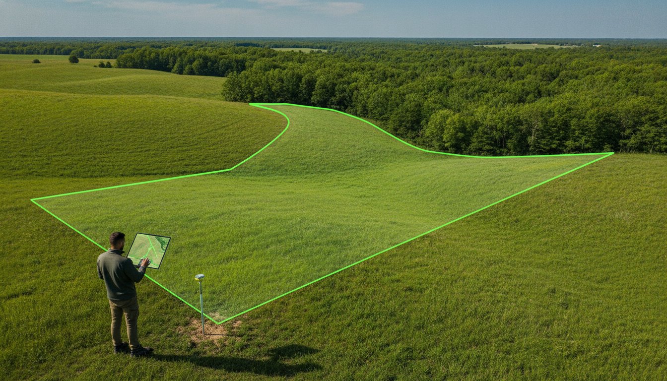
DIY Methods: Finding Physical Markers on Your Land
Transition from the office to the field. Once you have your plat map and deed in hand, you must verify the legal descriptions on the ground. Start at a known corner. This is usually the easiest point to identify, such as a road intersection or a clearly marked neighbor’s corner. From this point, you can follow the bearings and distances described in your deed. Finding physical evidence is the most satisfying part of learning how to find property lines on your own.
Bring a metal detector. This is your most valuable tool for raw land. Surveyors traditionally drive iron pins or rebar stakes deep into the earth at every corner. Over decades, these pins get buried under layers of leaf litter and topsoil. A standard metal detector will signal their location even if they are six inches underground. Don’t guess. Dig carefully when you hear a hit to confirm you’ve found a legitimate survey monument rather than scrap metal.
In wooded areas, look for blazed marks. Historical surveys often marked “witness trees” near the actual corner. These trees might have axe notches or painted rings that have partially healed over time. Cross-reference these marks with your property line app for confirmation. If you find a marker that matches your deed’s description, you have secured your boundary.
Common Physical Markers to Look For
- Iron pipes or rebar pins: These are the gold standard for corners. They are often topped with a plastic cap containing the surveyor’s license number.
- Concrete monuments: Used in more developed areas or for major boundary points. These are large, heavy, and nearly impossible to move.
- Brass caps: Often found set into concrete or large boulders. These represent permanent, high-precision survey points.
- Wooden stakes: These often have colored flagging tape. Treat these as temporary. They are used for active construction or recent scouting but aren’t permanent legal markers.
Using Technology as a Guide
Property line apps are excellent for getting you into the general vicinity of a marker. They use your phone’s internal GPS to overlay parcel boundaries onto a live map. This saves hours of wandering. However, you must understand the limitations of consumer hardware. Smartphone GPS accuracy can vary by up to 15-30 feet depending on tree cover and satellite positioning. Use the app to find the area, then switch to your metal detector for the final inches.
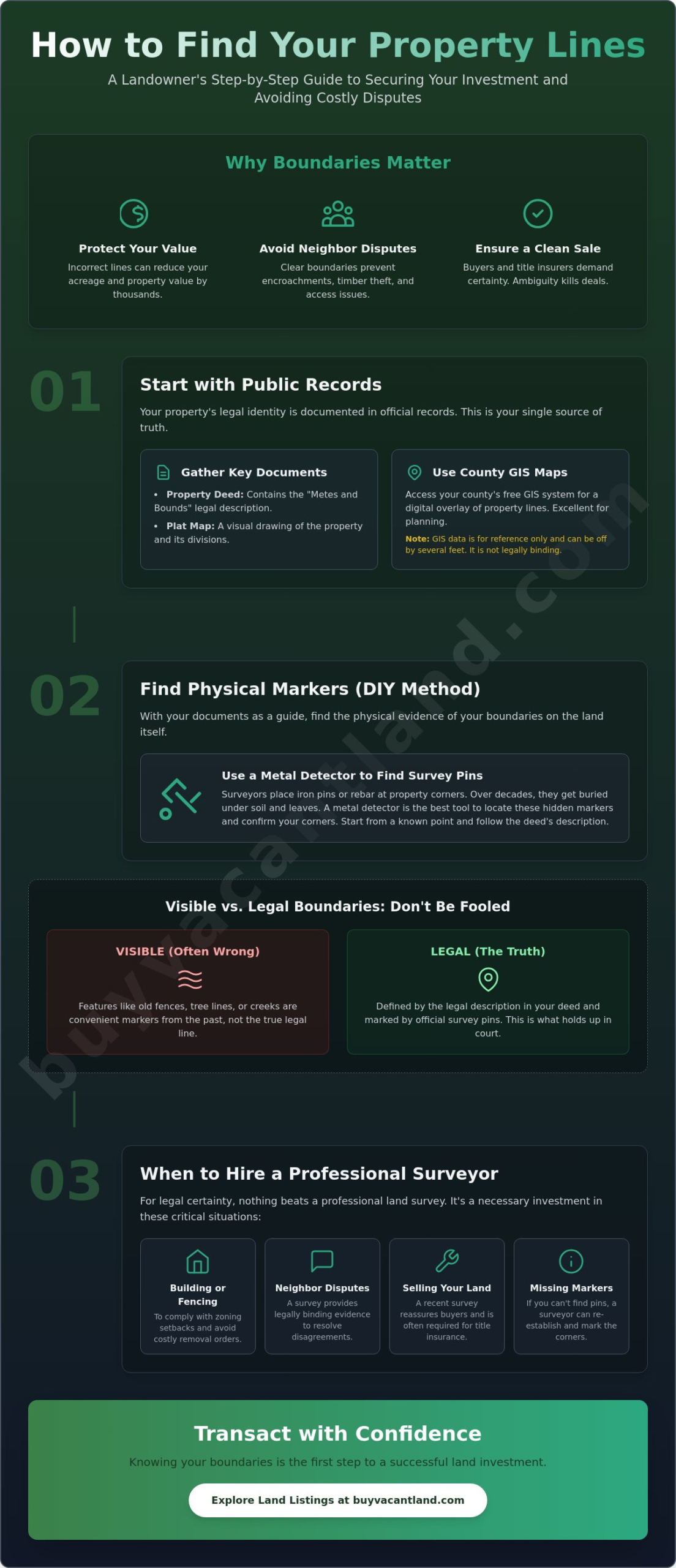
Professional Land Surveys: When You Need a Legal Determination
DIY tools are for discovery. A professional survey is for certainty. While apps and metal detectors help you scout, they do not hold weight in a courtroom or a title office. A professional survey is the only legally binding way to establish your boundaries. You must hire a licensed professional when you prepare to subdivide a parcel or begin physical development. If you are buying land, your lender will almost certainly require a survey before they fund the loan. This document protects your equity and ensures you aren’t paying for acreage you don’t actually own. Professional marking provides absolute peace of mind. It eliminates the friction of neighbor disputes and provides a clear, documented path to a successful closing.
Types of Land Surveys
Different projects require different levels of detail. A standard Boundary Survey is the most common choice for land owners. It locates the physical corners and lines of a specific parcel. For residential properties, these generally cost between $300 and $1,200. If you are dealing with commercial vacant land, you will likely need an ALTA/NSPS Survey. These are highly detailed and meet strict national standards. Because of the intensive research required, ALTA surveys typically cost between $2,000 and $5,000 or more. Finally, a Topographic Survey maps the “lay of the land.” It shows elevation changes and natural features. This is essential for engineers and builders. Expect to pay between $1,000 and $5,000 for this specialized data. Understanding how to find property lines through these professional channels ensures your project starts on solid legal ground.
Understanding the Cost of a Survey
Several variables impact your final invoice. Parcel size is the primary driver of cost. A 40-acre wooded lot requires significantly more labor than a half-acre cleared lot. Terrain density also matters. If a surveyor has to hack through thick brush to find a corner, the price goes up. Historical record availability is the third factor. If property records are difficult to locate or conflict with each other, an additional $500 to $1,000 may be added to the baseline cost for research.
View the survey as a strategic investment. It dramatically increases the sellability of cheap land for sale. Buyers hesitate when boundaries are vague. They move fast when they see fresh survey stakes and a recorded plat. To find a reputable surveyor, check your state’s licensing board or the National Society of Professional Surveyors database. Always request a written quote and a timeline before work begins. If you are ready to move your property, list your land today and show buyers exactly what you are selling. Mastering how to find property lines with a professional’s help is the fastest way to secure a clean, profitable transaction.
Preparing Your Land for Sale: Mapping Lines for Your Listing
You have done the hard work. You know how to find property lines using records and physical markers. Now, you must translate that data into a compelling listing. Buyers of vacant land are often looking from hundreds of miles away. They cannot walk the dirt today. Your listing must provide the clarity they need to make an offer. Include clear boundary photos and GIS overlays in your marketing materials. This eliminates the guessing game and positions you as a professional seller. It gives the buyer confidence to move forward without hesitation.
Transparency builds trust and speeds up the transaction. Disclose any known easements or boundary discrepancies immediately. If a utility company has a right of way through the back five acres, say so in the description. Buyers appreciate honesty. It prevents the deal from falling apart during the title search phase. Highlight your marked corners on the ground. Use bright flagging tape or fresh stakes. When a prospective buyer finally visits the property, they should find the corners exactly where your photos promised. This physical preparation makes the property significantly easier to tour and evaluate.
Visualizing Boundaries for Prospective Buyers
Standard ground level photos aren’t enough for raw acreage. Use drone photography to capture the full scope of the parcel. An aerial view with a red line overlay showing the property perimeter is the most effective sales tool you have. Create custom maps that clearly label access points, creek crossings, and utility locations. This level of detail is especially critical when selling owner financed land. Since you are effectively the bank, you must prove the value of the collateral to the buyer. Clear boundaries provide that proof. They show exactly what the buyer is paying for over time.
Ready to Sell Your Vacant Land?
Finding your lines is the first step toward a successful transaction. It removes the largest obstacle to a clean title transfer. A well-documented property sells faster and commands a better price. Don’t waste time on generic real estate sites that prioritize suburban houses. List your property on a specialized marketplace to reach targeted land buyers who understand the value of undeveloped acreage. You have the records. You have the markers. Now, you need the buyer. List your vacant land for sale today on BuyVacantLand.com and turn your asset into cash. Knowing how to find property lines has given you the competitive edge. Use it to close the deal.
Secure Your Boundaries and Finalize Your Sale
Now that your corners are marked and your maps are clear, it’s time to monetize your land. Don’t let your property sit idle. Use a specialized marketplace designed specifically for raw land to reach motivated buyers nationwide. You can connect directly with land buyers who value your documented boundaries and transparent data. We offer a national reach for all property types, from residential lots to off-grid acreage. Our platform bypasses traditional procedural hurdles to get your land in front of the right eyes immediately.
List your vacant land for sale on the #1 marketplace today. Your land is ready for a new owner. Take the final step and start your listing now to experience a swift, assured transaction.
Frequently Asked Questions
Can I find my property lines for free online?
Yes, you can access parcel boundaries through your county tax assessor’s GIS website or digital map portal. Most counties provide these records at no cost to the public. These maps offer a reliable digital overlay for scouting, though they are not legally binding for construction or fencing projects.
Is a fence always on the property line?
No, fences are frequently set back from the actual boundary to comply with local zoning ordinances or for maintenance convenience. Never assume a neighbor’s fence marks the legal edge of your land. Always verify the dimensions against your deed or a recorded plat map to avoid encroachment issues.
What do I do if my neighbor’s fence is on my property?
Address the encroachment immediately by presenting a professional survey to your neighbor. Most disputes are resolved through a simple boundary line agreement or by relocating the fence. Ignoring an encroachment can lead to adverse possession claims after several years, so take action to protect your equity now.
How accurate are property line apps?
Property line apps are accurate within a 15 to 30 foot margin of error depending on your device and satellite coverage. They are excellent tools for finding the general vicinity of a corner. However, they lack the precision required for legal determinations or building permanent structures near a boundary.
What is a plat map and where can I find it?
A plat map is a scale drawing of a subdivision or land parcel that shows precise boundaries, easements, and lot numbers. You can find this document at the county recorder’s office or often on the tax assessor’s website. It is a foundational document for anyone learning how to find property lines before a sale or development.
How much does a professional land survey cost in 2026?
A standard residential survey in 2026 averages $543, with most homeowners paying between $376 and $768. For larger vacant parcels or complex wooded terrain, costs typically range from $500 to $2,000. These rates depend on the size of the lot and the difficulty of locating historical survey markers.
Do property lines change over time?
Legal property lines remain static unless a new deed is recorded or a boundary adjustment is formally filed with the county. While physical markers might disappear and natural features like creek beds can shift, the legal description stays the same. Only a court order or a signed agreement between neighbors can alter these dimensions.
What happens if I can’t find my property pins?
You must hire a licensed surveyor to reset the pins using the coordinates found in the original plat. If pins are missing, you have no physical proof of your corners on the ground. A surveyor will use precision equipment to place new rebar stakes, ensuring you know exactly how to find property lines for future maintenance.


Join The Discussion