
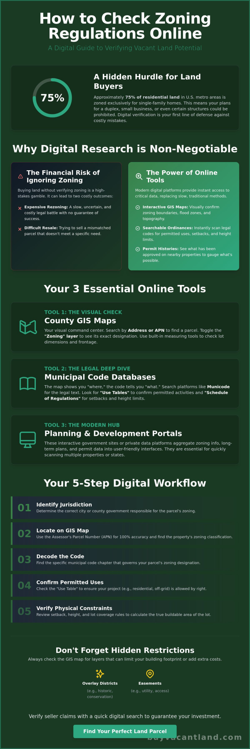
Approximately 75% of residential land in U.S. metro areas is zoned exclusively for single-family homes. This means your plans for a duplex, a small business, or even a specific type of shed could be illegal before you even break ground. You shouldn’t have to struggle with broken government links or wait weeks for a clerk to call you back. Learning how to check zoning regulations online is the fastest way to eliminate the risk of buying unbuildable land and wasting your capital.
You need a reliable way to verify property data without the stress of traditional bureaucracy. This guide provides the exact steps to master digital tools for any US parcel. You’ll learn to find specific zoning designations, understand permitted uses, and identify setbacks from your own computer. We will break down the process using GIS mapping, municipal code databases, and the newest 2026 interactive planning portals to ensure you get the facts you need immediately.
Key Takeaways
- Identify parcel boundaries and zoning layers using County GIS maps for immediate visual verification of land use rules.
- Discover how to check zoning regulations online to confirm permitted uses like residential or off-grid living before making an offer.
- Locate the correct city or county jurisdiction to find the specific Municipal Codes that govern your property’s development rights.
- Detect hidden restrictions such as overlay districts and easements that can limit your building footprint or add extra compliance costs.
- Verify all seller claims on BuyVacantLand.com with a quick digital search to guarantee the property meets your specific project requirements.
Why Digital Zoning Research is Your First Step Before Buying Land
Zoning regulations are the legal DNA of every vacant land parcel. They determine if your investment thrives or dies. Before you wire a single dollar, you must understand exactly what the local government allows. A parcel might look perfect for a residential lot, but if it is designated as agricultural or industrial, your plans are over before they begin. Knowing how to check zoning regulations online is the only way to protect your capital in a fast-moving market.
To understand the broader context of land use laws, you can review this overview of What is Zoning? which explains how these classifications evolved. Beyond the basic category, you need to identify physical constraints like setbacks, height limits, and lot coverage ratios. These numbers determine the actual buildable area of a lot. If a small lot has massive setbacks, you might not have enough room left for a foundation. Checking these details online prevents you from buying a lot that looks large but is functionally unbuildable.
The Financial Risk of Ignoring Zoning
Buying land without verifying the zoning is a high-stakes gamble. If you purchase a parcel for a specific project and later discover the zoning does not match, you face two bad options. You can try to rezone the property, which is a slow, expensive, and uncertain process. Or, you can try to resell a property that does not meet your needs. Finding the right lot initially is always cheaper than fighting City Hall. This is why we encourage sellers to verify zoning before listing their property on BuyVacantLand.com. It builds trust and ensures a clean transaction for everyone involved.
What You Can Find Online in 2026
Digital tools have replaced the dusty map books at the county office. In 2026, 71% of government organizations report using artificial intelligence to manage data, resulting in a 15% improvement in operational efficiency. This means most jurisdictions now provide interactive GIS (Geographic Information System) maps with real-time updates. You can access these tools to find:
- Interactive GIS Maps: Visual layers showing parcel-level detail and exact zoning boundaries.
- Searchable Ordinances: Full text of city and county land use laws that you can scan for keywords.
- Permit Histories: Data on previous variance requests and approvals for specific addresses.
This data shows you exactly what the neighbors have been allowed to do. It gives you a clear picture of what is possible for your own parcel without leaving your desk.
The Three Essential Online Tools for Zoning Verification
You don’t need to visit a city hall to verify property potential. In 2026, every piece of data you need is accessible via three primary digital channels. Learning how to check zoning regulations online starts with understanding these specific interfaces. These tools allow you to bypass slow government staff and get answers in minutes. Success depends on knowing which tool provides the visual data and which provides the legal text.
Mastering the County GIS Map
The Geographic Information System (GIS) is your visual command center. Search for your target parcel using the physical address or the Assessor Parcel Number (APN) for 100% accuracy. Once the parcel is located, toggle the “Zoning” layer to see the color-coded designation. High-performing GIS portals also offer layers for flood zones, wetlands, and topography. Use the built-in measuring tools to calculate road frontage or lot depth immediately. This eliminates the need for expensive preliminary surveys during your initial due diligence and provides instant clarity on the land’s physical potential.
Decoding Municipal Codes via Municode
Maps show you the “where,” but the code tells you the “what.” Most US jurisdictions host their legal documents on platforms like Municode or American Legal Publishing. This text provides the legal definition of a zoning ordinance for that specific area. Search these databases for “Use Tables” to see if your intended project is “Permitted by Right.” Look for the “Schedule of District Regulations” to find setbacks, maximum height, and lot coverage ratios. Watch out for “Conditional Uses.” These require a special permit and public hearing, which adds time and cost to your project.
Modern Planning and Development Portals serve as interactive hubs. These sites often host the latest 20-year residential plans, such as those required by the 2025 Wisconsin “Truth in Planning” Law. With 72% of local governments reporting difficulty filling vacant positions in 2026, these portals are now the primary way to access public records. If the government site is too clunky, proprietary land data platforms aggregate this data into a cleaner interface. These are helpful when you’re scanning multiple states for cheap land for sale. They simplify complex government feeds into digestible reports. This saves hours of manual searching and provides the peace of mind that your data is current. This multi-layered approach ensures you never buy a property with hidden legal flaws that could stall your development for years.
A Step-by-Step Workflow to Find Zoning Data for Any Parcel
Stop guessing and start searching. This five-step workflow is the professional standard for verifying land use from your desk. Efficiency is your goal. Follow this sequence to eliminate errors and secure the data you need for a confident investment.
- Step 1: Identify the jurisdiction. Determine if the property sits within city limits or an unincorporated area. City properties follow municipal rules; others follow county mandates.
- Step 2: Use targeted search strings. Don’t browse aimlessly. Type “[County Name] [State] GIS map” or “[City Name] Zoning Code” directly into your search engine to find official portals.
- Step 3: Locate the parcel. Use the Assessor Parcel Number (APN). It’s a unique identifier that never changes. Addresses for vacant land are often vague or unassigned, making the APN the only reliable search term.
- Step 4: Cross-reference the label. If the map shows a code like “R-1” or “A-2,” find the corresponding chapter in the Municipal Code. This text defines the specific rights and restrictions for that label.
- Step 5: Verify overlay districts. Check for secondary layers on the map. Environmental or historical overlays can override base zoning and add significant compliance hurdles.
Finding the Right Government Website
Distinguish between the Tax Assessor and the Planning Department. The Assessor tracks what the land is worth for tax purposes. The Planning Department dictates what you can do with it. Only trust sites with .gov or .org extensions to ensure the data is official. Always check the “Last Updated” date on the GIS interface. With 72% of local governments reporting staffing shortages in 2026, some digital maps may lag behind recent legislative changes. Relying on outdated data is a fast way to lose money.
Cross-Referencing Map Labels with Text
A map label like “Residential” is a trap. It’s too vague for a serious investor. You must find the specific definition for that label in the written code. “Low-Density Residential” might allow one house per acre, while “Medium-Density” could allow four. Look for the “Permitted by Right” list. These are uses allowed without a public hearing or special permission. If your project is on the “Specially Permitted” or “Conditional Use” list, prepare for extra fees and months of delays. This is how to check zoning regulations online without missing the fine print that could kill your deal. Verify these details before you browse BuyVacantLand.com for your next acquisition.
Interpreting Complex Regulations: Overlays, Easements, and CC&Rs
Base zoning is only the first layer of the legal landscape. You might find a parcel zoned for residential use, but secondary regulations can still block your project. Learning how to check zoning regulations online requires you to look past the primary color on a GIS map. You must identify the specific overlays and private restrictions that override standard city code. Ignoring these details leads to expensive legal battles and stalled construction.
One critical development in 2026 is the impact of state-level overrides. For example, California SB 79, which took effect July 1, 2026, upzoned properties within a half-mile of transit stops. This law allows qualifying residential projects to override local land use regulations entirely. You must verify if state laws or local overlays apply to your specific parcel to understand its true value.
The Impact of Overlay Zones
Overlay districts add a second set of rules to a property. These are often used for environmental, historical, or aesthetic protection. Common overlays include floodplains, wetlands, and steep slope protections. If your land falls within a historical preservation overlay, the city may dictate your building materials and architectural style. Conversely, some overlays provide benefits. Identifying an “Enterprise Zone” on a digital map can reveal tax incentives and fast-tracked permitting for your development. Always toggle every available layer in your GIS tool to see these boundaries clearly.
Private vs. Public Restrictions
A city might grant you permission to build, but private rules can still say no. Covenants, Conditions, and Restrictions (CC&Rs) are private agreements that “run with the land.” These are not usually found on a zoning map. You must find these documents online through the County Recorder or Clerk of Court website. These private rules often cover:
- Minimum square footage for homes.
- Prohibitions on certain livestock or outbuildings.
- Restrictions on off-grid living or mobile homes.
A municipality does not enforce CC&Rs; neighbors or Homeowners Associations (HOAs) do. This is why a professional title search is a mandatory supplement to your online zoning research. It uncovers easements and rights-of-way that physical maps might miss. These legal paths allow utility companies or neighbors to cross your land, effectively reducing your buildable area. Verify these restrictions early to ensure your project is actually viable. Once you have cleared these hurdles, you can confidently find your next parcel on our marketplace and move toward a fast, secure closing.
Non-conforming use is another factor to watch. This happens when a property’s current use was legal when it started but no longer matches new zoning laws. These “grandfathered” properties are common but risky. If the structure is destroyed or the use stops for a set period, you may lose the right to continue that use. Check the local ordinance for “discontinuance” clauses to see how much time you have before the grandfathered status expires.
Using Zoning Data to Evaluate Properties on BuyVacantLand.com
Data is useless unless you apply it. Now that you know how to check zoning regulations online, you can use this skill to filter listings with surgical precision. Don’t waste time on properties that don’t fit your vision. Our marketplace allows you to scan thousands of parcels, but your personal verification is what secures the deal. Perform a quick 5-minute check on any listing to confirm the seller’s claims before you reach out. This habit protects your time and your capital.
Information gives you leverage. If you discover a hidden setback or an overlay that restricts building, use that data to negotiate. You can often find better deals on cheap land for sale by identifying parcels with minor zoning hurdles that others overlook. Understanding the difference between a “permitted” use and a “conditional” one allows you to spot opportunities where others see obstacles. Knowledge is your primary tool for cutting through market noise and finding real value.
Due Diligence for Buyers
Your search for owner financed land should always begin with a zoning check. Sellers offering financing are often more flexible, but the land must still meet your legal needs. Ask direct questions about utility access and previous zoning verifications. If a seller can’t provide an APN, move on to the next listing. Use our comprehensive guide on how do you buy land to ensure you have a complete checklist for every transaction. This ensures you never miss a critical step in the due diligence process.
Maximizing Value for Sellers
Transparency sells land faster. If you are listing a property, include the specific zoning designation in your description. Don’t just say “residential.” Use the exact code like “R-2” and explain what it means. This builds immediate trust with serious buyers who also know how to check zoning regulations online. They will appreciate the effort and move toward a closing more quickly. High-quality data reduces friction in the sales process.
Visual proof is even better. Attach screenshots of the County GIS map and the specific “Use Table” from the municipal code to your BuyVacantLand.com listing. If the land allows for Accessory Dwelling Units (ADUs), highlight that fact. With over 80,000 ADUs permitted in California alone since 2016, this is a massive selling point for investors. Position your parcel as “Ready to Build” by citing the exact codes that allow for immediate development. This clarity attracts qualified leads and eliminates time-wasting questions from unsure buyers.
Secure Your Investment with Digital Due Diligence
Zoning verification is no longer a slow, manual process. You now have the exact workflow to verify any US parcel using GIS maps and searchable legal codes. Mastering how to check zoning regulations online ensures you never buy a lot that can’t support your project. Identify the jurisdiction, toggle the GIS layers, and cross-reference the legal text to confirm your rights immediately. This process eliminates the risk and stress of traditional land buying by giving you the facts before you commit capital.
Take control of your portfolio with data-backed decisions. We offer a specialized vacant land marketplace focused exclusively on raw and undeveloped land. This creates a direct connection between buyers and sellers for a fast, efficient transaction. Stop guessing and start verifying your next acquisition with confidence. Our platform removes the traditional hurdles of property ownership by putting the data in your hands.
Start your land search on BuyVacantLand.com today. Your next successful build starts with a single search.
Frequently Asked Questions
Can I find zoning regulations for any property in the US online?
Most jurisdictions now provide digital access to land use data. As of 2026, 71% of government organizations report using artificial intelligence to manage public records, which has significantly improved data availability. While some extremely remote rural counties may still require a phone call, digital portals are the professional standard for the vast majority of US parcels. Always start your search at the county level to find the most accurate digital tools.
What is the difference between a zoning map and a zoning ordinance?
The zoning map is a visual tool that shows the geographic boundaries of different districts. The zoning ordinance is the written legal code that dictates what you can actually build within those boundaries. You must use both to understand how to check zoning regulations online. The map identifies your parcel’s designation, while the ordinance defines the specific setbacks, height limits, and permitted uses for that code.
How do I find my property’s Assessor Parcel Number (APN) online?
Locate your APN by visiting the County Tax Assessor’s website and searching by the physical address or the owner’s name. This number is a unique identifier that ensures you are looking at the correct piece of land. APNs are essential for GIS mapping because vacant land often lacks a traditional street address. Record this number immediately to streamline all future digital research and permit applications.
What should I do if the online zoning map and the written code contradict each other?
The written municipal code almost always carries more legal weight than a visual map. If you find a conflict between the two, contact the local Planning Department to request a formal clarification. Many investors secure a Zoning Verification Letter to resolve these discrepancies. This document provides a written guarantee of the property’s status and protects you from future legal disputes or building permit denials.
Are online zoning maps updated in real-time?
Most digital maps are updated on a periodic schedule rather than in real-time. Always check the “Last Updated” date on the GIS interface to verify the freshness of the data. In 2026, 72% of local governments report difficulty filling vacant positions, which can lead to delays in digital record updates. If a major zoning reform was recently passed, the digital map might not reflect those changes for several weeks.
How do I know if my land is in a flood zone or environmental overlay?
Open the “Layers” or “Legend” menu on the County GIS map to reveal environmental data. You can toggle specific layers for FEMA flood zones, protected wetlands, and steep slope restrictions. Identifying these overlays is a critical step in how to check zoning regulations online because they can override your base zoning rights. These environmental factors often determine if a lot is buildable or if it requires expensive mitigation.
Can I change the zoning of a property once I buy it?
You can apply for a rezoning, but the process is slow, expensive, and never guaranteed. Local boards evaluate these requests based on the city’s long-term comprehensive plan and community impact. It is far more efficient to buy land that already fits your intended use. Use the data found online to identify properties that meet your requirements today rather than gambling on a future legal change.
What is a “variance” and can I apply for one online?
A variance is a legal exception to a specific zoning rule, such as a request to build closer to a property line than normally allowed. Most modern “GovTech” portals now allow you to submit variance applications and pay fees directly through their website. You must prove that the existing zoning creates a unique hardship for your specific parcel. Check the planning department’s digital portal for the specific application requirements and hearing schedules.


Join The Discussion